Bryan asked about the installation northeast of China’s Jiuquan Satellite Launch Center (酒泉衛星發射中心) in the post about Chinese replica of CCK AFB. Jiuquan Satellite Launch Center, aka Eastwind Space Campus (東風太空城), was built where Shuang Cheng Tzu Missile Center (雙城子飛彈測試中心) used to be. The installation Bryan asked about used to be the Surface-to-Air Missile (SAM) site.
Before CHEN, Huai’s epic U-2 mission to photograph Shuang Cheng Tzu on January 13, 1962, the US already had had images of the missile center on hand, obtained by one of the CORONA satellite missions. However, the poor quality and small scale precluded the possbility of detailed analysis. This was why the US wanted to cover it by the U-2.
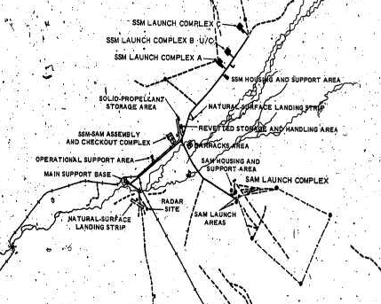
Although the satellite images had been obtained in 1961, it took time to analyze and interpret the images and the National Photographic Interpretation Center (NPIC) did not publish the interpretation report until March 1962. The report fixed the location of the missile center at 41.05N, 110.15E and located it on the following map:

The report also included a map of the missile center. You may compare it with the current Google Maps image.

The 1961 CORONA image of the SAM site is below. Note the small scale:

The image obtained by CHEN, Huai was of better quality, despite the obliqueness:

From both images, you can see that the launch sites were not of the familiar Star-of-David configuration:

Why the differences? It is possible that the Soviet Union gave the Chinese a different design or the Chinese designed the SAM site by their own. I think the former is more likely because I doubt that the Chinese had the capability to design the launch site at that time. According the Chinese book 飛鳴鏑, PLA conducted a live SAM test in August 1959 at Shuang Cheng Tzu.
BTW, Globalsecurity.org has a CORONA image mosaic taken in April 1972:
http://www.globalsecurity.org/space/world/china/images/4c_eastwind_mozaic_01.jpg
Actually, it looks like SAM and AAA test sites.
Anyway, been on PLA SAM/S-300 battery/base hunt in the last few nights. Here’s what I come with.
South of Beijing
http://maps.google.com/maps?f=q&hl=en&q=+39%C2%B034%2737.22%22N+116%C2%B045%2738.86%22E&ie=UTF8&ll=39.577006,116.760794&spn=0.003792,0.008497&t=k&om=1
http://maps.google.com/maps?f=q&hl=en&q=+39%C2%B033%2746.41%22N+116%C2%B024%2754.03%22E&ie=UTF8&ll=39.562892,116.415008&spn=0.003792,0.008497&t=k&om=1
Close to Taiwan
http://maps.google.com/maps?f=q&hl=en&q=+24%C2%B034%276.23%22N+117%C2%B039%2737.69%22E&ie=UTF8&ll=24.568397,117.660469&spn=0.004474,0.008497&t=k&om=1
http://maps.google.com/maps?f=q&hl=en&q=+24%C2%B030%274.05%22N+117%C2%B052%2736.17%22E&ie=UTF8&ll=24.501125,117.876714&spn=0.004476,0.008497&t=k&om=1
http://maps.google.com/maps?f=q&hl=en&q=+21%C2%B023%277.36%22N+110%C2%B011%2732.12%22E&ie=UTF8&ll=21.385378,110.192256&spn=0.00458,0.008497&t=k&om=1
Another S-300 battery base under construction. Just north of Xiamen, Fujian. That’s the 3rd base/battlion in the regiment in the area.
http://maps.google.com/maps?f=q&hl=en&q=+24%C2%B040%277.01%22N+118%C2%B016%2759.15%22E&ie=UTF8&ll=24.668614,118.283097&spn=0.00447,0.008497&t=k&om=1
Possible S-300 site, under early construction.
http://maps.google.com/maps?f=q&hl=en&q=+29%C2%B018%2724.95%22N+120%C2%B0+7%2754.61%22E&ie=UTF8&ll=29.306931,120.131836&spn=0.00429,0.008497&t=k&om=1
Bryan