
花蓮港南飛行場位在當今的吉安鄉,從上面的照片可以看到木瓜溪以前的位置。以下是「台灣區各飛機場要圖」中的飛行場平面圖,畫得有點簡陋,我發現除了標出的特掩體、附屬施設地、(?)爆通信所之外,從美軍的空照圖上還可以看到許多飛機用的掩體,甚至還有一條疑似鐵路跟東線鐵路主線連接。
The former Karenko South Airdrome was located in Ji’an Township, Hualien County. The following drawing from the 1945 Taiwan Area Airdrome Plans was rather simplified. Many other facilities that were found on WWII reconnaissance photos were missing from the drawing.

利用空照圖繪製的花蓮港南飛行場平面圖如下,不同的設施已用不同形狀或顏色的符號標出。
Based on old reconnaissance photos, I made the following airdrome plan on Google Earth. The various facilities were represented by symbols of different shape or colors.

北面六個較大的圓圈就是要圖中所謂的特掩體所在,雖然要圖上總共畫了十個特掩體,我在空照圖上只能找到六個。北面十個較大的圓圈就是要圖中所謂的特掩體所在,雖然要圖上總共畫了十二個特掩體,我在空照圖上找到十個。從下面這張照片來看,特掩體跟現代的機堡很像,不過應該沒有留存下來吧。
The ten large circles indicate the “special revetments” (特掩體) referred to by the 1945 airdrome plan, although there were twelve such revetments in the original drawing. They were similar to the hardened aircraft shelters that are found on modern air bases.

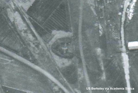
空照圖上看不出來飛行場要圖所指(?)爆通信所的樣貌,但我在照片上對應的位置發現了八個整齊排列的標記,由於在好幾張照片上都看得到,所以應該不是底片受損的痕跡。也許它們是某種天線的位置吧?另外我在著陸區北面對應要圖中ピスト的位置也找到一模一樣的標記,麻煩熱心的網友協助指認這些標記的目的。
I found eight markers on the south side of the landing area. At first I thought they were scratches of the film. But since they were neatly positioned, they must serve some purposes. Later I found similar markers on the north side. Anyone knows their functions?
下面第一張照片是著陸區南面的標記,第二張則是著陸區北面的標記,其中還可以看到兩座特掩體。
The first picture below shows the markers on the south side, while the second shows those on the north.


著陸區西緣總共有九個方形的掩體,我在Google Earth照片上以白色方框表示。下面這張照片裡還看得到兩架飛機(箭頭所指),其中一架已明顯受損。現在這裡是知卡宣森林公園。
On the west side of the landing area, there were nine square revetments (indicated by white squares on the above Google Earth image). Currently there is a forest park called Cikasuan located at this place. In the following WWII photos, there were two Japanese aircraft, one of which was obviously damaged.

白色三角形表示V字型飛機掩體的位置,這種掩體在許多其他的飛行場上都看得到,以下照片的掩體裡可見一架飛機。
The large white triangles in the Google Earth image represent the V-shaped aircraft revetments that could be found on many other WWII-era airdromes on Taiwan. An airplane can be seen in the next photo.

黃色較小的三角形代表某種V字型的掩體,因為這種掩體比前一種掩體窄小,所以不確定它們真正的用途。以下照片的掩體裡雖然有一架飛機,但是這架飛機看起來很胖,不像是真的飛機,也許這種小掩體其實是用來當作欺敵的誘餌。
The smaller yellow triangles indicate the locations of another type of V-shaped revetments. These revetments were smaller those mentioned above. The following photos shows one of these revetments with an “aircraft” in it, which looked like a decoy.
Google Earth照片飛行場西北角有一條灰色的細線,代表疑似鐵路的路線。下圖是這條鐵路(箭頭所指)跟東線鐵路會合的地方。
The thin gray curve on the Google Earth image represents a railway. The following image shows where the track merged into the main line.

下圖是主營區西南角的空拍照片,箭頭所指的建築很像在後龍飛行場發現的防空洞,一個個的圓形結構也出現在後龍飛行場,極有可能是蓄水池。可惜這些建築結構都已經從地貌上消失。
In the following photo of the southwest corner of the main support area, there were seven structures which were similar to those air raid shelters found on Koryu Airdrome. The circles might be some kind of ponds. Unfortunately, they have all been erased from the landscape.

上個月去花蓮遠雄海洋公園玩的時候,途經吉安附近,知道以前這裡有座飛行場,但因還沒畫出平面圖,所以不知道相對位置。現在終於知道,當時車子就沿著飛行場東緣的界線開過。
這兩天在花蓮港南飛行場的空照圖上又有新的發現,已經修改原文,並增加照片。敬請參閱!
板主你好
所謂(?)爆通信所,依我所知,應為耐爆通信所
同樣的字出現在國史館光復初期之土地接收與處理
p385台東飛機場耐爆通信兵舍施設地
p386台東飛機場耐爆指揮所及附屬施設地
有多耐爆不知
我猜耐爆之最高等級應該是鳳山通信隊吧
潮州東機場往山林那塊疏散地感覺很神秘喔
原來是「耐」,謝謝您的指正!
Mr. Chang:
您好,小弟有幸看到您對台灣天空的歷史投入的心血和深入的記錄研究! 這讓小弟深感敬佩…
由於小弟對於飛行相當的有興趣,投入在微軟的模擬飛行(fsx)世界中已有一段時間。
近日興起製作台灣機場的計劃,特別是想要進行”台灣消失中的機場”設計專案,將這些機場製作為可供起飛和降落的場景…希望能貢獻自己的一份小小力量,帶給飛行同好有關台灣古早的記憶並留下相關的機場資料,讓大夥別忘了過去…
因此小弟提起勇氣,希望能得到您的相關支援。
由於小弟將會參考您的文獻和照片,
在您許可範圍下,
有機會能轉貼和引用您網站上的”文字”、”照片”等。
小弟當然也會註明相關出處…
謝謝您花費寶貴的時間閱讀此留言!
小弟曾在”玉山航空論壇”的”場景製作暨飛機塗裝工作室”
完成6個台灣戰備跑道的專案,希望您能給小弟一些指教!謝謝…
我認為您的構想很棒!
如果能透過電腦技術,讓這些已經消失的機場在虛擬的世界中重現,應該可以讓更多年輕一代的人了解這一段過去吧。
照片您就拿去用。這些照片是中央研究院從美國的國家檔案局取得的,所以不論我或中研院都沒有這些照片的版權,但因為它們是美國政府拍的照片,所以拿來用應該是不會有問題的。
至於文字方面,我這邊也沒有問題。
I can’t believe it! You have just posted the info I have been trying to locate for the past several weeks! I have the same set of pics from US Berkley that I acquired when we were searching for the Karenko POW Camp, and thought they’d be useful in confirming the location of the airbase. However, I have not yet been able to confirm which IJAAF units were stationed at Karenko South. Do you have this information also? Furthermore, if there is a Karenko South, then where is “Karenko North”?
I am an American known as “Colonel FOG” at the ROCAF 401st TCW (12th Recce Sqdrn) in Hualien, where I have lived for six years. I recently completed working an assignment at AIDC in Taichung.
Can can an English speaker associated with this airdrome investigation/project please contact me ASAP?! I wish to assist you in this research in any way I can. I can speak some Manadarin, but very little, and cannot read your web postings without assistance.
Is there some way that I can join Academia Sinica in a “honorary” fashion?
A quick web search using “Karenko, Formosa, Kamikaze” should bring you to a website for World War II Forums where I (Colonel FOG) have recently been posting requests for information on this airdrome.
maine_sciguy@yahoo.com
Orrin: I have no information on the units stationed at Karenko South. There was indeed Karenko North, which was located at the current Hualien air base.
I am not affiliated with Academia Sinica. So I am not sure if someone can join it in an honorary fashion or in other ways.
Wei-bin, watch out for this Orrin guy. He’s the guy that tried to spread a rumor of a PLAAF KJ-2000 defecting/landing at Tainan AB 2 year ago, on multiple internet sites. And his job with ROCAF is just teaching some English…
http://taiwanbbs.org/cgi/index.pl?b=mil,m=1256969643
I don’t know why ROCAF keep him around, he’s a security risk…..
洪致文教授的部落格證實還有一些特掩體留了下來。
新年快樂^^請問一下.是否可以跟您請教一下這張航照圖與上大和機場的航照圖的編號嗎??謝謝
新年快樂!
我過幾天回覆你。
您好:
看了您的文章,讓我很是感動,這真是不容易的工作。我現在正在找有關日治時期日軍防護總督府及台北橋的防砲陣地資料.We are going no where 或許你可以指點方向。
感謝萬分。
Sarah
I am still interested in working on a project related to Japanese kamizakes bases in Taiwan, especially the ones at Karenko and Yilan.
@Bryan C – You instantly came off as a jerk, and by posting this insult two years later, I see that that hasn’t changed at all. In that previous episode, I was ASKING if anyone could confirm what someone I knew had firmly declared was a genuine photo he took of a KJ-2000 landing at Tainan. All you did was give me a load of crap for ASKING about it. With the assistance of several people, we got to the point where the photo was proven to be a dupe, but the source leading to a photoshopped version of it being placed on his computer as a replacement for a similar photo he took of something in the sky that day has never been determined. It must be old news by now, so why don’t you ask YOUR CIA coworkers what they know about it?
我目前有看到飛行第17,19,204戦隊在戰爭結束時都在花蓮, 可惜沒有資料指出在那個機場.
我對組織單位沒有研究, 但我猜是在花蓮港南.
版主你好
特掩體有留下一兩個
請搜尋 “知卡宣 防空洞”就會有圖片了 ^ ^