我曾經提過陸軍湖口基地中興台的位置過去似乎有飛機跑道的存在,而且懷疑是日軍在日據時代建造的。現在我確定我的猜測沒錯,但是我在CORONA衛星照片上看到疑似跑道的物體卻不是日據時代的遺跡。 In a previous post, I wrote that the Japanese might have built an airfield at the current location of the base of ROC Army 542nd Armored Brigade in Hukou Township. I was correct in that there indeed used to a Japanese airfield during WWII. However, the narrow “runway” I saw on the CORONA satellite images was not the work of the Japanese.
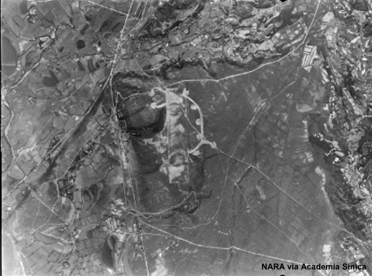
上面這張美軍在1945年拍攝的照片裡的飛行場,位置就在湖口基地中興台,不過當時美軍沒有為它命名,美軍的偵察照片上的註記是「A/D 4 MI. N.E. Shinchiku」(新竹東北方4英哩的機場)。這可能是因為它的規模較小,跑道長度只有一公里左右(鹿港飛行場長約兩公里),露天機堡大約只有11座。 The above reconnaissance photo, taken by American aircraft in 1945, shows the Japanese airfield at the time. But it was only marked as “A/D 4 MI. N.E. Shinchiku” on the film. (Shinchiku is the Japanese pronunciation of Hsinchu.) It was unnamed probably due to its relatively small size. Its length was only about 1000 meters, whereas Rokko Airdrome was 2000 meters in lenght. There were only 11 revetments.
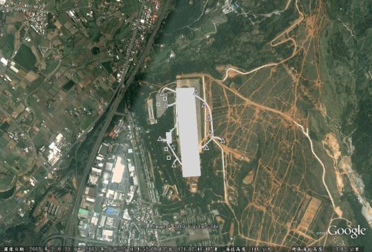
利用Google Earth的疊圖功能,我畫出這座飛行場的平面圖,下圖裡面的三角形就是露天機堡的位置,四個正方形則對應到我在照片上發現的四個正方形區塊(我猜是高射砲的位置)。有興趣找出這座飛行場確切位置的朋友可以下載kmz檔。 With the help of the reconnaissance photo, I drew the airfield plan on Google Earth. The triangles represent the revetments, while the four square symbols indicate the four square pads I found on the photo. I guess there were pads for anti-aircraft guns, but I could be wrong. If you are interested, you may want to down the kmz file.