
Source: Formosa Interim Report, February 1944, via Academia Sinica
上面這張高雄鳳山地區的空照圖攝於1943年12月20日。在英文字「W/T」的旁邊有一塊顏色較深的「y」字形區域,美軍情報人員並沒有在報告中對這塊區域作任何註解,應該是當時掌握的情報仍不足以判別其用途。
The above aerial photo of Hozan (currently Fengshan, Kaohsiung) was taken by USAAF aircraft on December 20, 1943. To the right of the word “W/T” is a y-shaped area. It was hard to tell if it was of any significance from the photo and the 1944 document Formosa Interim Report did not say anything about it.
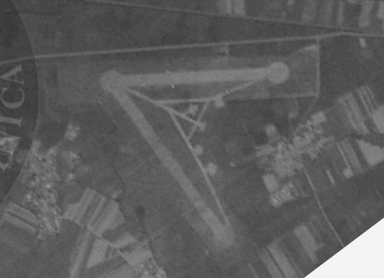
在以下這張1944年3月拍攝的空照圖中,可以看到在原來的「y」字形區域中建築了兩條相交成「V」字形的跑道,每條跑道兩端都有供飛機迴轉的圓形區域(turning circle),「V」字形的正中間還有幾條滑行道和五座露天飛機掩體。不過美軍的情報分析認為這座機場只能供輕型機使用,甚至還懷疑它根本就是誘敵用的假機場。
The same area was photographed by USAAF again in March 1944. The new reconnaissance photo (see below) revealed that two runways forming a “V” had taken shaped and turning circles were at both ends. In addition, five revetments were at the center of the “V”. However, the American intelligence analysts concluded this airfield was only suitable for light use and believed it was mostly likely a decoy.
Source: NARA via Academia Sinica 中央研究院臺灣文史資源海外徵集與國際合作計畫「美國國家檔案館典藏臺灣舊航空照片」
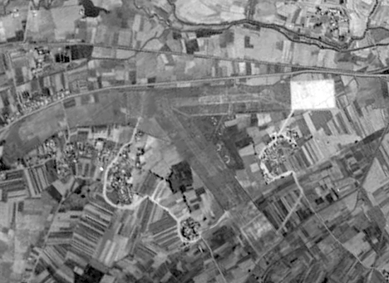
到了1945年1月,美軍飛機再度拍下這座機場的空照圖(如下),新的照片顯示之前美軍的結論可能下得太早:在過去的幾個月裡,日軍擴建了鳳山飛行場,將場區的「y」字兩個頂點向外延伸,原有呈「V」字形的跑道似乎被刨除,但多了幾條疏散飛機的滑行道,只是從照片看不出是否也增建了飛機掩體。
The next photo, taken in January 1945, suggested that the Americans intelligence officers might have rushed to the conclusion, as modifications had been carried out on this airdrome. It had been expanded by extending the tips of the “y”. Furthermore, the original V-shaped runways had been scraped off and several taxiways had been built. But it is difficult to tell from the photograph whether there was any newly built revetments.
Source: NARA via Academia Sinica 中央研究院臺灣文史資源海外徵集與國際合作計畫「美國國家檔案館典藏臺灣舊航空照片」
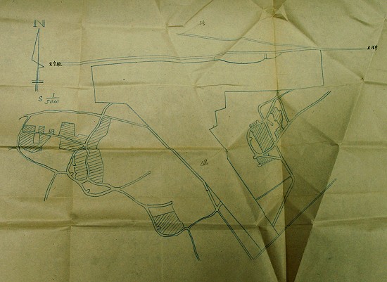
鳳山飛行場在戰後移交給中華民國政府,移交的機場要圖指出其擴建工程從1944年8月1日開始,至同年12月完成。機場要圖文字說明有六座小型飛機掩體,但從下面的要圖中卻畫了不止六座。
After the WWII, Hozan Airdrome, along with supporting documents, was turned over to the ROC government. One document indicates that the expansion work had started in August 1944 and had completed in December of the same year. The same document also says that there were six small revetments, although more than six can be found in the following drawing.
Source: Taiwan Area Airdrome Plans 台灣區各飛機場要圖
我把鳳山飛行場的位置繪製在以下的Google Map上,各位可以用滑鼠在地圖上移動。
The location of the former Hozan Airdrome is shown on Google Maps below. You can explore the neighborhood using the mouse.
在較大的地圖上查看鳳山飛行場 Hozan Airdrome