
Source: AFHRA via Academia Sinica 中央研究院臺灣文史資源海外徵集與國際合作計畫「美國空軍歷史研究部徵集成果」 (Formosa Interim Report)
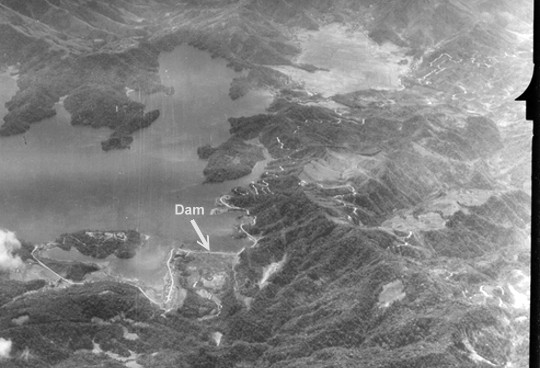
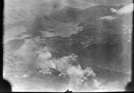
The following photo, looking south at Jitsugetsu Tan (Sun Moon Lake), was taken on March 23, 1945, the day of massive bombing by USAAF B-24 heavy bombers. The location of Target 181 Suisha Dam is indicated by the arrow (by me), which is at the northwest corner of Jitsugetsu Tan.
下圖是1945年3月23日美軍B-24轟炸日月潭當天,由北往南方向拍攝的照片,水社堰堤就在箭頭所指Dam的位置,也就是日月潭的西北角。照片畫面看起來十分靜謐,但這只是暫時的景象...
Source:NARA via Academia Sinica 中央研究院臺灣文史資源海外徵集與國際合作計畫「美國國家檔案館典藏臺灣舊航空照片」 (G03489)
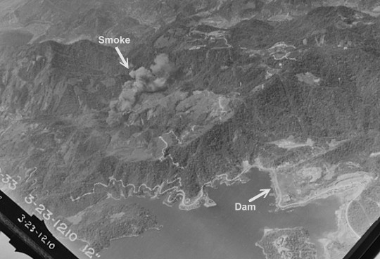
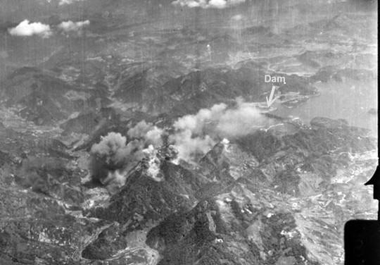
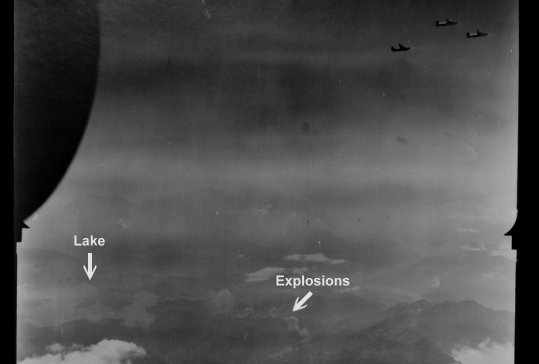
Moments after the above photo was taken, bombs started to fall on the west side of the lake. Although Shuisha Dam was listed as a target in the intelligence report, none of the bombs hit the dam on this day. It seemed the American had purposedly spared the dam.
下面這張照片的拍攝時間應該比上圖稍晚,因為照片裡已經可以看到炸彈爆炸產生的濃煙。雖然水社堰堤被美軍列為181號目標,當天卻沒有炸彈直接落在壩上,可能是美軍決定不炸水社堰堤了。
Source:NARA via Academia Sinica 中央研究院臺灣文史資源海外徵集與國際合作計畫「美國國家檔案館典藏臺灣舊航空照片」 (G03489)
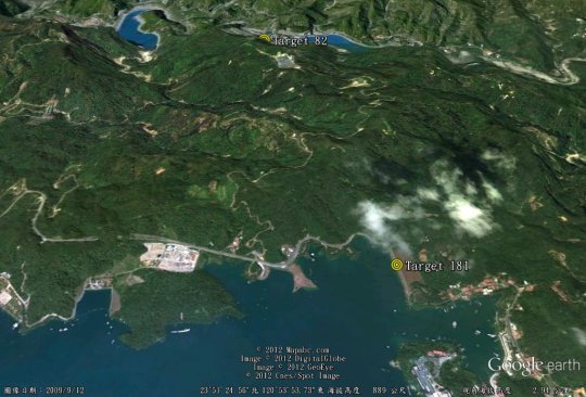
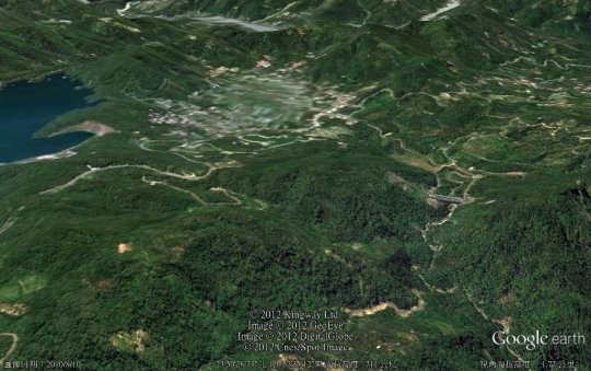
View the corresponding area in the above photo with Google Earth:
下圖是用Google Earth來看上面照片裡相對的區域。
Source:Google Earth
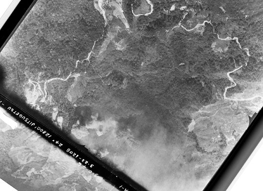
The following vertical photo covered the area to the west of the explosion in the above photo.
以下這張垂直拍攝的照片也可看到炸彈爆炸的濃煙,位置大約比上一張照片的爆炸地點再偏西一些。
Source:NARA via Academia Sinica 中央研究院臺灣文史資源海外徵集與國際合作計畫「美國國家檔案館典藏臺灣舊航空照片」 (G03489)
You may want to explore the neighborhood of the area corresponding to that in the above photo with the following embedded Google Maps.
以下嵌入的Google Maps所涵蓋的區域與上圖相當,有興趣的朋友可以利用它來探索附近地區。
Looking south from the northwest of Jitsugetsu Tan, there were many more explosions:
從日月潭西北方往南拍攝的照片,可見已有多處被炸。
Source:NARA via Academia Sinica 中央研究院臺灣文史資源海外徵集與國際合作計畫「美國國家檔案館典藏臺灣舊航空照片」 (G03489)
Google Earth satellite image of the area in the above photo:
以Google Earth來看上面照片裡相對的區域:
Source:Google Earth
In the photo below, Jitsugetsu Tan is on the right-hand side.
以下這張照片是從水里上空往東北方拍攝,日月潭就位於照片的右半部。
Source:NARA via Academia Sinica 中央研究院臺灣文史資源海外徵集與國際合作計畫「美國國家檔案館典藏臺灣舊航空照片」 (G03489)
With the help of Google Earth, we can see that the American aircraft bombed the area stretching from Suisha Dam (Target 181) to Jitsugetsu Power Plant No. 1 (Target 82), the bombing of which will be covered in my next blog post. So stay tuned.
利用Google Earth比對,可以發現美軍飛機從水社堰堤(181號目標)的方向一直炸到日月潭第一發電所(82號目標)附近。我的下一篇貼文就會分享當時第一發電所被炸的景象。
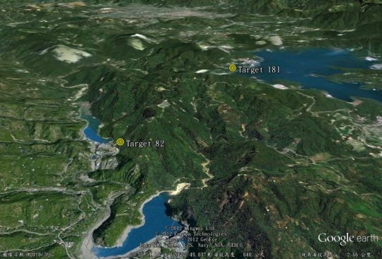
Source:Google Earth
USAAF B-24 overflew the target area.
執行轟炸任務的B-24高飛在日月潭區上空。
Source:NARA via Academia Sinica 中央研究院臺灣文史資源海外徵集與國際合作計畫「美國國家檔案館典藏臺灣舊航空照片」 (G03489)
(To be continued. 未完待續。)
那天我們可以實地去看
只是你的時間太晚
5年前還有些殘跡
林前輩:
沒能看到殘跡當然可惜, 不過幸好還能夠從這批照片中感受到當年轟炸的激烈. 我還有第二發電所被炸的部分還沒上網, 這部分更為慘烈.
謝謝您的指教!
你寫的炸彈濃煙地方地名是咸菜甕, 那地方本來有漂亮木造茶場, 前幾年被拆掉真可惜!!
我聽說日本人曾在那裡偽裝電廠
但從空照寫真
那有辦法欺騙
從美軍的情報分析報告來看, 他們對日月潭的發電設施位置掌握得滿清楚的.
Hello, this is Wade Mart; I think Michael Hurst told you about me. My uncle died on this mission and I would very much like to have copies of this photos. i can’t download them or copy them though. can you call me at 2834-xxxx….