
雖然這張在高空拍攝的照片解析度不佳,但能在找了一年多之後發現這張1944年3月台南飛行場照片,讓我興奮不已。除了因為找了很久,另一個原因是檔案管理局保存的「台灣區各飛機場要圖」中,並沒有這座飛行場(及其他台南地區飛行場)的資料。詭異的是,在日本的アジア歴史資料センター(亞洲歷史資料中心)找得到這些台南地區飛行場的呈繳資料(但沒有平面圖),卻沒有台灣其他飛行場的資料。不禁讓我懷疑,台南地區飛行場的呈繳資料當初是不是不小心被日本人帶回去了。
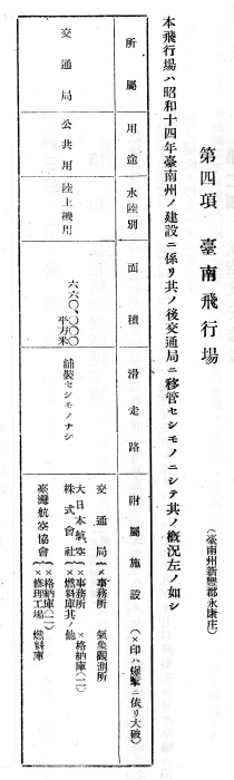
Although the quality of the above high-altitude reconnaissance photo is less than ideal, it took me more than a year to find this rare photo of Tainan (Eiko) Airdrome. It is strange that the Taiwan Area Airdrome Plans preserved in Taiwan’s National Archives do not include this airdrome as well as several others in the Tainan area but they can be found in Japan Center for Asian Historical Records. These documents referred to this airfield as “Eiko Airdrome” (Eiko is the Japanese for Yungkang). The following table, extracted from the Summary of the Rule of Taiwan published by (Japanese) Taiwan Governor, called it Tainan Airdrome. The table also listed the facilities that can be seen on the west side of Eiko Airdrome in the above photo.
日軍的呈繳資料將這座飛行場稱為「永康飛機場」,不過在台灣總督府編印的《台灣統治概要》則將它稱作「台南飛行場」。上圖中可以看到飛行場西側有兩塊長方形區域,比較靠北面那一區裡還可以看到一些場站設施。下面這張《台灣統治概要》的表格列舉了這些設施的明細,只是除了氣象觀測所,其他都被盟軍炸壞了:
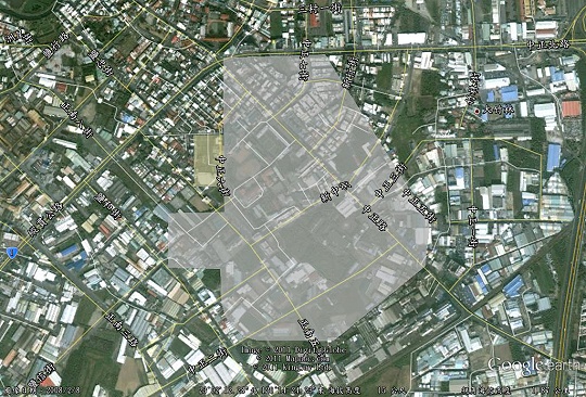
下圖是將台南飛行場繪製在Google Earth上的結果,除了幾條周邊道路,幾乎沒有任何遺跡留下。有興趣進一步探索的朋友可以按此下載kmz檔,或是上Google Maps探索。
In the following Google Earth overlay, only several roads from the Japanese colonial period can be found while the airdrome itself had been completely vanished. You may want to download the kmz file to further explore this area on Google Earth or on Google Maps.
FYI: I have a bunch of old Taiwan airport photos posted at my Taiwan Digital Archive. You are welcome to use any photo you find interesting on your blog.
There is a map of the Tainan Einansho Airport near the bottom of this page:
http://taipics.com/maps.php
also check:
http://taipics.com/mediapubs_ww2.php
http://taipics.com/airports.php
marc: Many thanks for the links. I will cover Einansho in another post later.
場站設施區的區域,目前是砲校對嗎?
我沒有到過現場,也不清楚砲校在哪裡。這個問題可能可以從洪致文教授的部落格得到答案。
TBF來炸永康的影片
http://www.criticalpast.com/video/65675074361_TBF-Avenger-bombers_Eiko-airstrip_aerial-view-of-towns_bombing-airstrip
JP:這不是永康,而是麻豆。
請看http://taiwanairpower.org/blog/?p=3441
場站設施現在是永康測候所