台灣西部的主要城市在日治時期都設置了競馬場,只可惜這些競馬場在戰後一座也沒留下來。弔詭的是,反而是當時日本的敵人──美國──幫我們保留了這些競馬場的影像。以下就是我在美軍偵察照片上找到的台北、新竹、台中、嘉義、台南、高雄、屏東等七座競馬場空照圖,另外我也在Google Maps上繪出這些競馬場的位置,讓各位比較和憑弔。
There used to be horse racing tracks in major cities on Formosa when the island was under Japanese rule. After the end of WWII, these tracks were either abandoned or converted to other functions. Consequently, none of them exist today. In the following, I collate reconnaissance photos of these horse racing tracks taken in WWII by the Americans and compare them with current Google Maps satellite images. Enjoy.
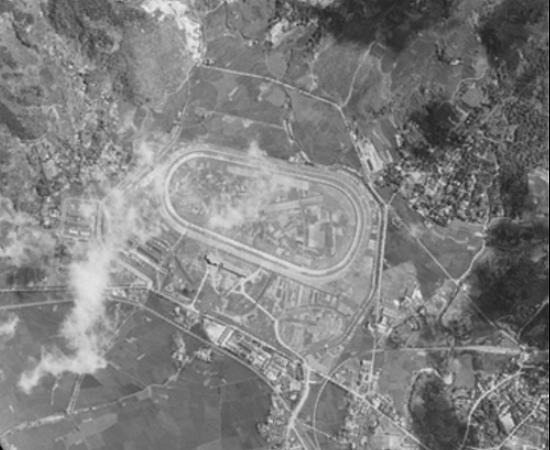
台北競馬場 Taihoku (Taipei)
以下台北競馬場的照片攝於1945年6月18日,戰後這裡設立了政治作戰學校。
The following photo was taken on June 18, 1945. The Chiang Kai-Shek government built the Political Warfare Academy at this location after the war.

Via 中央研究院美國國家檔案館典藏臺灣舊航空照片
在較大的地圖上查看昭和時期台灣的競馬場 Horse Racing Tracks on Formosa in the Showa Period
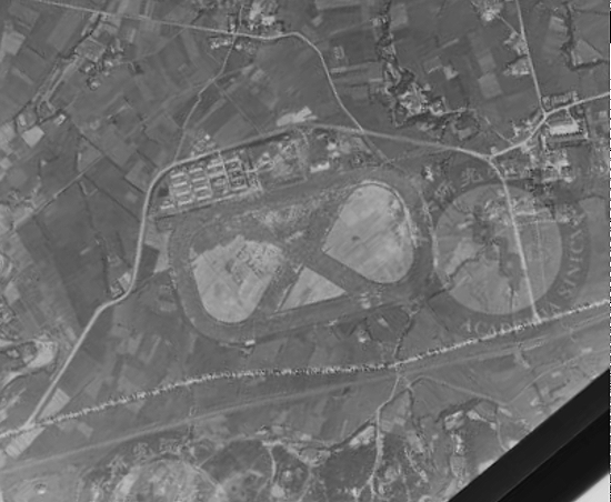
新竹競馬場 Shinchiku (Hsinchu)
這張新竹競馬場的照片攝於1945年7月11日,過了一個多月,戰爭就結束了。
This photo of the Shinchiku track was taken on July 11, 1945, only one month before the war ended.

Via 中央研究院美國國家檔案館典藏臺灣舊航空照片
在較大的地圖上查看昭和時期台灣的競馬場 Horse Racing Tracks on Formosa in the Showa Period
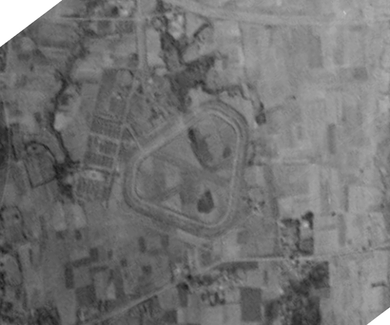
台中競馬場 Taichu (Taichung)
台中競馬場的這張空照圖攝於1944年3月1日,戰後這裡設立了著名的成功嶺基地。
The race track in the following photo of March 1, 1944, was converted into an Army base after the war.

Via 中央研究院美國國家檔案館典藏臺灣舊航空照片
在較大的地圖上查看昭和時期台灣的競馬場 Horse Racing Tracks on Formosa in the Showa Period
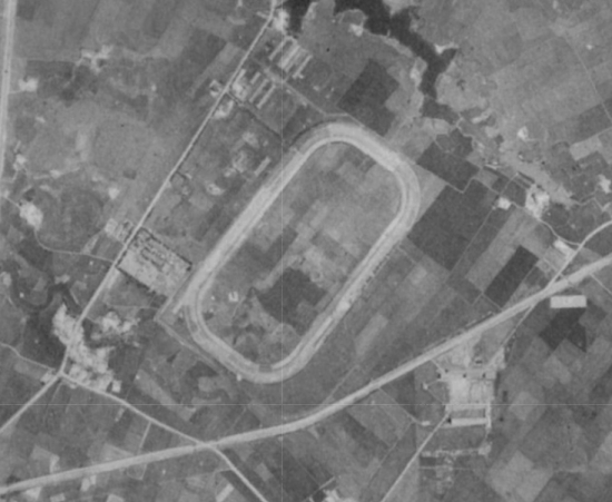
嘉義競馬場 Kagi (Chiayi)
以下這張1945年1月18日的嘉義競馬場照片是美軍以傾斜照相方式拍的,在它下方的Google Maps衛星照片上可以看到位於原來競馬場右半邊的建築物排列成一個明顯的弧形。
This oblique photo of the Kagi track was taken on January 18, 1945. In the Google Maps satellite image below it, you can see the buildings on the right half of the oval track after the war form a perfect arc.

Via 中央研究院美國國家檔案館典藏臺灣舊航空照片
在較大的地圖上查看昭和時期台灣的競馬場 Horse Racing Tracks on Formosa in the Showa Period
台南競馬場 Tainan
台南競馬場的造型最為獨特,下面這張照片攝於1944年3月1日。
This March 1, 1944, oblique reconnaissance photo shows the unique configuration of the Tainan race track.

Via 中央研究院美國國家檔案館典藏臺灣舊航空照片
在較大的地圖上查看昭和時期台灣的競馬場 Horse Racing Tracks on Formosa in the Showa Period
高雄競馬場 Takao (Kaohsiung)
這張高雄競馬場空照圖的確實拍攝日期不詳,只知道是1945年。
The exact date on which the following photo was taken is unknown. The year was 1945.

Via 高雄市百年歷史地圖
在較大的地圖上查看昭和時期台灣的競馬場 Horse Racing Tracks on Formosa in the Showa Period
屏東競馬場 Heito (Pingtung)
美軍在1944年拍攝這張照片之前,屏東競馬場很可能就已經廢棄了,因為競馬場的輪廓已經很模糊,之後拍攝的偵察照片上完全都看不出這裡曾經有過競馬場。
Most likely the Heito track had been abandoned before the following annotated photo was taken in 1944, probably due to its proximity to Heito Airdrome (part of the runway can be seen on the upper part of the photo). Nothing reminiscent of the racing track can be found on the photos taken in later years.

Via 高雄市百年歷史地圖
在較大的地圖上查看昭和時期台灣的競馬場 Horse Racing Tracks on Formosa in the Showa Period
台南競馬場,光復後被省農會接收,後來賣給台南紡織,現在該處為正在興建中的「南紡夢時代購物中心」。
Thanks for a very interesting post. I always wondered where these race tracks were. I thought the main one was in Wanhau on the riverside.
There are a couple of horse race photos about 3/4 of the way down this page. you are welcome to post any images that you find useful for your very interesting Taiwan history articles: http://taipics.com/parks_beaches.php