
Source: Formosa City Plans via University of Texas at Austin
本文一開始的地圖是澎湖本島旁的測天島(Sokuten To),繪製於1945年。多年來由於填海造陸,原本以橋樑銜接的測天島已經併入澎湖本島,如同Google的衛星照片所示。測天島原名小案山,日治時期之初被更名為測天島,日軍並在此興建海軍基地。下文取自美軍1943年的情報分析文件,其中提到案山海軍基地的設施包括一座400呎x70呎的乾塢、修理廠、無線電站、水雷與魚雷庫房、燃油與煤炭儲存設施、加油設施。
The 1945 map at the top was that of Observatory Island of Pescadores (now Penghu). After years of land reclamation, Observatory Island is now an integral part of the larger Penghu Island, as can be seen in the Google satellite image above. Observatory Island was originally named Little Ansan. Shortly after Formosa and Pescadores were ceded to Japan, the Japanese government renamed the island and then built a naval base here. A short description of the naval base can be found in the following 1943 intelligence report:

Source: NARA via Fold3.com
1944年10月12日,從美國海軍第38特遣艦隊起飛的戰機除了轟炸台灣本島上的目標,澎湖的海軍基地也是他們攻擊的目標。下面這張在當天拍攝的測天島照片顯示有濃煙從乾塢東邊冒出,顯然有設施被擊中。
On October 12, 1944, aircraft from Task Force 38 of the US Navy attacked Pescadores as well as Formosa proper. In the next photo, a plume of smoke can be seen streaking from the east side of the dry dock at Ansan naval base.

Source: NARA via Fold3.com
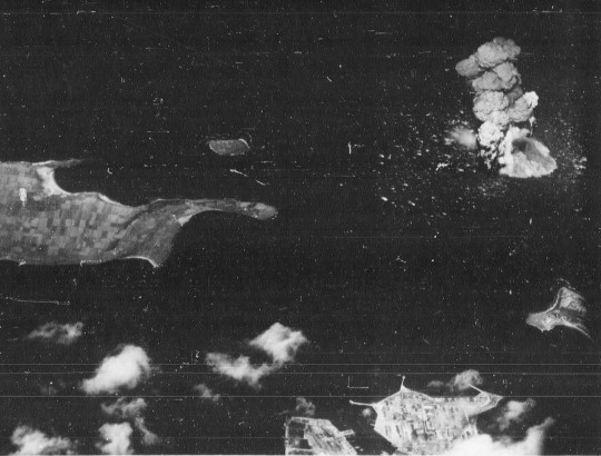
下圖中,一艘日軍的彈藥船在測天島西方被美軍的SB2C Helldiver直接命中,引發強大的爆炸。測天島就在照片的右下角。
The next photo shows that a SB2C Helldiver scored a direct hit on a Japanese ammunition ship, leading to a spectacular explosion. Observatory Island can be seen in the lower-right corner of the photo.
Source: NARA via Fold3.com
從不同角度拍攝的爆炸場面,測天島在照片的中右方:
Another photo of the same explosion. Observatory Island appears in middle right.

Source: NARA via Fold3.com
在下面這張攻擊後拍攝的照片中,箭頭所指之處就是前面照片乾塢東邊被炸的地方,乾塢中可見兩艘軍艦。
In the following post-strike photo, the arrow points to the east side of the dry dock where the smoke was streaking from in a previous photo. Note the two ships in the dry dock.

Source: NARA via Fold3.com